Reomte Sensing Basic
Remote sensing is a branch of geo-spatial science that deals with gathering information about the environment from a distance using different kinds of sensors mounted on aircraft, spacecraft, satellites or Unmanned Aerial Vehicles (UAVs). There are two types of sensors: active or passive. With active sensors (e.g. radar) energy is transmitted from the sensor to provide their own illumination. Passive systems (e.g. optical sensors) rely on an external energy source (for example the sunlight) for illumination and function in the optical part of wavelength spectrum. These wavelengths are useful for distinguishing objects on the earth’s surface and can be used to generate images of the earth over a relatively large area at low cost. Multi-spectral optical satellite sensors commonly used for detailed mapping include Landsat, and Sentinel-2, which offer publicly available, moderate resolution images. Very high resolution images are provided by commercial providers such as Planet, QuickBird, and DigitalGlobe.
Before start, we need to know the following basic remote sensing concepts.
Spatial Resolution:
The spatial resolution specifies the pixel size of satellite images covering the earth surface.

Clipping
Temporal Resolution:
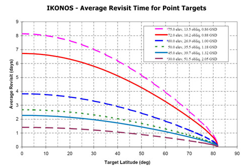
Clipping
Spectral Resolution:
Clipping
Digital Number (DN)
Radiance, Reflectance, and Top of Atmosphere (TOA)

Clipping
Landsat 8
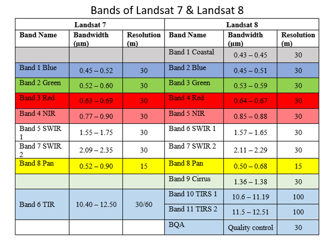
Landsat 8 launched on February 11, 2013 and acquiring images of entire earth every 16 days in an 8-day offset from Landsat 7.Landsat 8 measures different ranges of frequencies along the electromagnetic spectrum - a color, although not necessarily a color visible to the human eye. Each range is called a band, and Landsat 8 has 11 bands. Out of which seven bands are consistent with the Thematic Mapper (TM) and Enhanced Thematic Mapper Plus (ETM+) sensors found on earlier Landsat satellites (Landsat 7 and 5/4), providing for compatibility with the historical Landsat data, while also improving measurement capabilities. Two new spectral bands, a deep blue coastal/aerosol band and a shortwave-infrared cirrus band, have added to Landsat8 for allowing scientists to measure water quality and improve detection of high, thin clouds.
Clipping
Sentinel 2
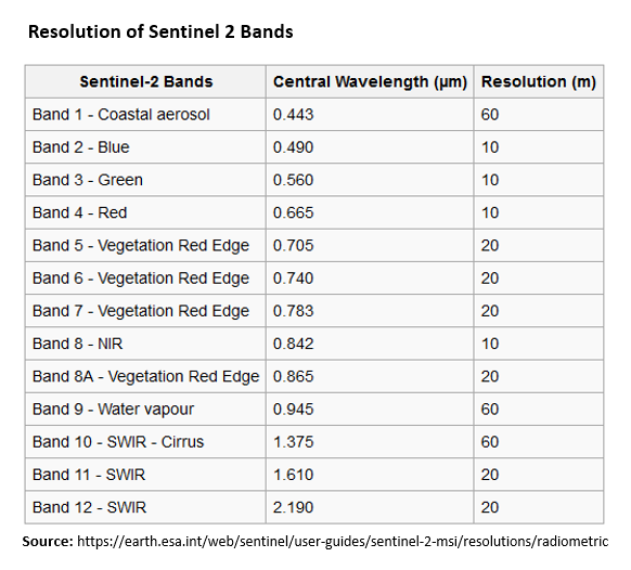
Sentinel-2 was launched by European Space Agency on 23 June 2015 and Sentinel-2B on - 07 March 2017 for Land monitoring. These two satellites provide high resolution optical imagery globally every 10 days with one satellite and 5 days with 2 satellites.The spatial and radiometric resolution of Sentinel-2 imagery varies by spectral band. Sentinel-2 data are acquired in 13 spectral bands. These area:
- four bands at 10 m: Band 2, Band 3, Band 4, and Band 8
- six bands at 20 m: Band 5, Band 6, Band 7, Band 8a, Band 11, and Band 12
- three bands at 60 m: Band 1, Band 9, and Band 10
Clipping
Synthetic Aperture Radar (SAR)
In synthetic aperture radar (SAR) imaging is on kind of active sensing system by is microwave pulses are transmitted by an antenna towards the earth surface. The microwave energy scattered back to the spacecraft is measured. The SAR makes use of the radar principle to form an image by utilising the time delay of the backscattered signals.
Sentinel 1 SAR
Two Sentinel 1 SAR Satellite were lunched by European Space Agency for Land and Ocean monitoring. Sentinel-1A was launched on 3 April 2014 and Sentinel-1B on 25 April 2016 . The another goal of this mission is to provide C-Band SAR data continuity following the retirement of ERS-2 and the end of the Envisat mission. These satellites carry a C-SAR sensor (C-band Synthetic Aperture Radar), which offers medium and high resolution imaging in all weather conditions. The C-SAR is capable of obtaining night imagery and detecting small movement on the ground, which makes it useful for land and sea monitoring.
So there are many numerous choices of remote sensing data. However, we’ll only focus on freely available Landsat-8 and Sentinel-2. You can access these data from following sources: